.png)

Main Navigation

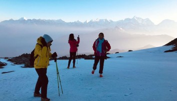
Everest Base Camp – Cho La – Gokyo Trek is the perfect adventure for those looking to get away from the bustle of the crowds and experience the pristine nature and true wilderness of the Everest region. It is a comprehensive trek through the central Khumbu region of Nepal Trek that includes four high altitude climbs.
The trek offers amazing views of four 8000-ers, namely, Everest (8848m), Makalu (8463m), Lhotse (8516m) and Cho Oyu (8201m) along with the Khumbu icefall and Ngozumpa glacier. You will also witness the serene Gokyo valley from the fantastic vantage point at Gokyo Ri along with the tranquil waters of the Gokyo Lakes. The trail passes through the Sagarmatha National Park, which is a sanctuary for a variety of endangered Himalayan wildlife including red pandas, snow leopards, musk deer, Himalayan thars, Lophophorus and so on.
A short flight from Kathmandu to Lukla leads to the start of the classic EBC trek. The route follows trails through Sherpa villages beneath towering landscapes to the highest summer village of Gorak Shep: springboard for Base Camp and close Everest views. Once above the tree line, you will be closer to the ice-giants than on any other trail. The trekking days are designed to minimize the risk of AMS by limiting daily altitude increases. Three rest days are included. The first is at Namche Bazaar: explore the town and nearby Khumjung to experience the culture, lifestyle and beliefs of the Sherpa People.
Trek to the hilltop village of Tengboche which has a vibrant Buddhist Monastery. Continue through Pangboche to Dingboche for the second acclimatization day: walk to Nangartshang Gompa ridge for superb views of the Nuptse glacier, Ama Dablam’s north face and Makalu. As the altitude rises, temperatures fall: forests and farmland give way to alpine scrub, then rock and ice. After a night at Lobuche trek to the highest village at Gorak Shep for lunch. Follow the trail to the ring of peaks surrounding the upper Khumbu Glacier. Base camp is laid out each April-May on the ice, opposite the ice fall. Return to Gorak Shep for the night.
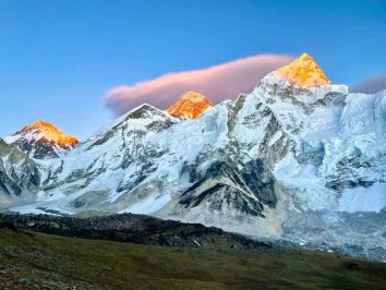
A pre-sunrise Kala Patthar climb from your teahouse offers glorious views that include Cho Oyu in the west, Everest, the South Col, Lhotse, Nuptse and the peaks surrounding the Base Camp.
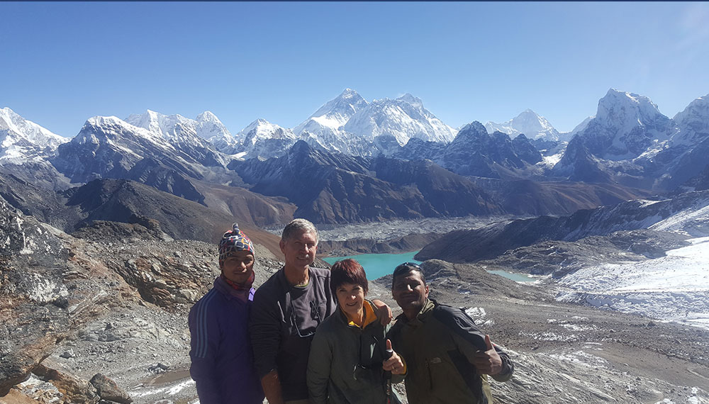
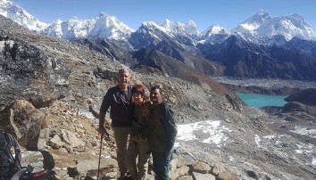
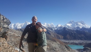
Return to Lobuche, descend the Khumbu Glacier then follow the route to lower Dzongla and a rest. Tackle the demanding Cho La and descend to Tagnag above the Ngozumpa Glacier. Walk along the glacier to Gokyo, and enjoy an afternoon at the lake. Tackle Gokyo Ri for sunrise and superb (different) views of Cho Oyu, Everest’s northeast face, Lhotse, Nuptse and Makalu et al. Return to Lukla in three days. The Everest Base Camp – Cho La – Gokyo Trek comes to a closure with a flight back to Kathmandu.
The best times to perform the Everest Base Camp – Cho La – Gokyo Trek is during the months of March – May (spring season) and September – November (autumn season). During these periods, the weather is generally stable with moderate temperatures and clear skies. This will provide you with the best views along with the most convenient trekking experience. The unpredictable weather and rain of monsoon season and harsh temperatures and snowfall of winter can make the trek tough and dangerous. Therefore, we advise that you perform this trek during the spring and autumn seasons instead.
This 18-Day Everest Base Camp – Cho La – Gokyo Trek is a strenuous trek that takes you up to altitudes of 5554m (Kalapattar). It is more challenging than the classic EBC trek as the route is lengthier and involves crossing a high pass at Cho La (5420m). You will be trekking over rocky hills and semi mountainous terrain for most of the trek. This trek is recommended for physically fit trekkers with some prior trekking experience.
NRS. 3000 ($30) per person
Khumbuu Pasang Lhamu Rural Municipality
NRS. 2000 ($ 16) Per Person
NRS. 1000 ($10) for organized trekkers
NRS. 2000 ($20) for independent trekkers
After completing passport, immigration and visa requirements, we will meet you outside the terminal building (look for your name board) and transfer you to your 3* hotel: afternoon free. Evening: a welcome dinner, introduction to your guide and a briefing on the trek with a check on necessities.Overnight at hotel.
Take a day tour to five of the Kathmandu Valley’s cultural world heritage sites: Swayambhunath, the famed “monkey temple;” the city’s historical Durbar Square with ancient temples, unique art, architecture, and the chance to see the Kumari (living goddess); Patan’s Durbar Square; the Hindu temple Pashupatinath and Bouddhanath, the world’s largest stupa.
A car and driver will take you to each site-entrance and wait for you. (Entry tickets and lunch are not included.)
After breakfast, drive to the Domestic Airport for the flight to Lukla in the Khumbu region – south of Everest. Meet your local porters and begin the discovery by trekking into the DudhKoshi Valley: to Cheplung (2 700m) and Ghat (2 530m). Another hour’s walk takes you to Phakding. Overnight in Phakding
Walk through pine forests along the DudhKoshi, crossing tributaries, to the Sherpa villages of Benkar (2 710m), Chumoa (2 820m), Monjo (2 840m) and Jorsale (2 830m). This is the gateway and permit checkpoint to the Sagarmatha National Park. Thamserku (6 618m) glistens east of the village. Follow the river to its confluence with the BhoteKoshi: the major rivers draining the Khumbu District. Climb steadily, crossing the high Tenzing-Hilary Bridge, to the first glimpses of Everest and the Nuptse-Lhotse ridge. A further three hour forested climb leads to the Sagarmatha national park’s administrative and trade centre at Namche Bazaar. Overnight in Namche Bazaar.
This is the first scheduled acclimatization day. Acute Mountain Sickness (AMS) experts recommend at least a 24 hr rest period. Keep active: climb high and sleep low is the acclimatisation advice.
Only Namche offers ATMs, cyber cafés, restaurants and bakeries, plus a colourful market each Friday evening and Saturday morning. The Sagarmatha (Everest) National Park Visitor’s Centre has informative displays on Sherpa culture, local flora and fauna.
The village of Khumjung (3 780m) will present a more traditional view of Sherpa life than Namche. Spend a morning walking up to the village. A circular trail is possible. At very least, visit the closer Everest View Hotel (3 880m).
A more adventurous five hour trek west to Thame (3 820m): below the impressive KongdeRi Ridge (6 187m), offers panoramic Himalayan landscapes not visible from the Gokyo or Everest trails.
From the top of Namche, the trail contours around a hill to Sanasa (3 780m); and a trail fork: NW to Gokyo, NE to Everest. Look for Himalayan tahrs on high ground, shy spotted deer, and birds – including the colourful (male) national bird: the Danphe pheasant. Descend to water driven prayer wheels at PhunkiThenga (3 250m): the lowest point north of Namche. Cross the DudhKoshi near its confluence with the Imja Khola and climb steeply for 2 hours up the Imja Khola Valley through rhododendron and dwarf conifers to the hilltop village of Tengboche.
Good views from the village include the Everest group. There is an important monastery that is well worth visiting. At October’s full moon the colourful, Mani Rimdu festival is held; with Tibetan Opera and masked dancing. Overnight in Tengboche.
Descend to the scattered stone village of Debuche (3 820m): with a nunnery. Cross the Imja Khola to the north bank and gradually ascend to Pangboche (3 860m) with views of towering AmaDablam (6 856m). The trail follows the river to its confluence with the Lobuche Khola and continues to Dingboche: the last year-round settlement in the region. Walled terraced fields protect barley, buckwheat and potatoes from icy winds and marauding animals during the short growing season at this altitude. Overnight in Dingboche.
To acclimatise: head north to the NangkartshangGompa ridge (4 800m) for views of the Nuptse Glacier, ChhukhungRi (4 230m), the Lhotse glaciers and ImjaTse (6 189m). Further east, along the Mahalangur Himal Ridge, is imposing Makalu (8 463m). Towards the south is, AmphuLapcha’s fluted ridge (5 845m) and the unusual view of AmaDablam’s north face and glaciers. Return to the teahouse in Dingboche.
Ascend slowly to a ridge and the hamlet of Duse (4 500m) with western views of Taboche and Cholatse. Continue through kharkas to Duglha (4 620m). Then ascend the Khumbu Glacier’s huge stony terminal moraine (1 hr). Landmark balanced-stone memorials to lost climbers have been placed along its rim. [To the west the start of the Cho La trail is visible.]To the north, border peaks along the Mahalangur Himal include, Pumori, Lingtren, and Khumbutse. Everest is hidden by the imposing Nuptse-Lhotse wall. [The icefall and CWM lies at an angle of ~140o E of north – thus when viewed from the south, or Gokyo in the west, Everest is seen rising behind the Nuptse-Lhotse wall.] Continue to and overnight in Lobuche.
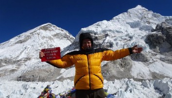
A desolate trail along the moraine heads for the last, seasonal, village of Gorak Shep below Pumori. After an early lunch, trek to cold EBC: positioned on the Khumbu Glacier opposite the dreaded icefall – the most nerve wracking section of an Everest ascent.
During the April-May ascent season, porters scurry in and out with supplies like an army of ants and the site is a riot of colourful tents perched on the dirty ice. Out of season it is bleak and silent, bar birds wind and avalanches. From Base Camp, Everest and the Cwm are hidden behind the West Ridge. Walk back to Gorak Shep for the night.
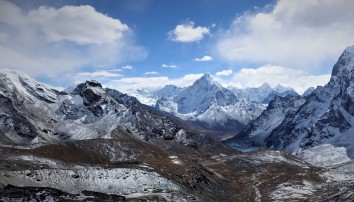
From the village, a pre-dawn 400m climb (2-3 hrs return) up Kala Patthar, offers sunrise on Everest (8 848m/29 028ft), Lhotse (8 516m), Nuptse (7 861m) and Changtse (7 550m, north of the Rongbuk Glacier). Then Pumori (7 145m), Lingtren (6 697m) and Khumbutse (6 623m) amidst countless other peaks that crowd your horizon. Cho Oyu (8 201m) can be seen further to the west.
After breakfast: retrace your steps to Lobuche (4 940m) and the landmark memorials on the glacier’s snout. Descend the moraine and follow the trail around the foot of Awi Peak into the Cholatse Valley. Head northeast, past the Cho La Tsho, to Dzongla. Rest and overnight in Dzongla.
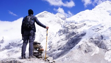
From Dzongla, the trail meanders across the narrowing, boulder strewn, valley towards steep rock faces. The 600m ascent begins with an impressive scramble up boulders to a low point on the ridge beyond which is the snout of the Cho La Glacier. The glacier gradually curves to the west towards the flag-bedecked pass-summit – which is reached via a short scramble. If the ice is firm, the route is not difficult.
Summit views to the west include KyajoRi and Pharilapche standing out amidst other peaks. To the north the high border ridge of the Mahalangur Himal presents the vast white wall from Cho Oyu in the west across Ngozumpa II and I to Ghyachung Kang whose ice fields form the Ngozumpa Glacier. [In 2014, Tenzing Peak (7 916m) and Hilary Peak (7 681m) were proclaimed to the left and right of Ngozumpa II.] These peaks are all above 7 600m. To the southeast Cholatse and AmaDablam, dominate the impressive skyline.
The descent to Tagnag is in complete contrast and needs care: loose scree slopes, initially over hidden ice, drop steeply into the valley and a distant bushy knoll. Sporadic cairns mark a ‘route’. Beyond that the trail descends grassy slopes more sedately to the summer village of Tagnag above the Ngozumpa Glacier. Overnight in Tagnag.
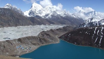
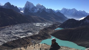
Below the village is the kilometre wide, rubble-covered Ngozumpa Glacier, Nepal’s longest at 26km, gouged out over aeons from the walls of towering peaks on its eastern flank. Ascend to its rim and follow the trail(s), gradually descending towards the grey rubble-covered ice (which slows melting). Irregular cairns mark routes that later cross the ice and ascend the western bank. DudhPokhari and Gokyo come into glorious view ahead – with Cho Oyu as backdrop.
Consider a walk north of the village towards Cho Oyo. The trail rises gently for ~1½ hrs to the largest of the region’s six sacred lakes; ThonakTsho. continue to the NgozumpaTsho and Scoundrel’s Viewpoint on a low hill. From here there are closer views of Cho-Oyu, the ice wall and Ghyachung Kang, the sheer glacier-cut wall of the KangchungShar pyramid et al, plus Everest, Lhotse and Nuptse. The Cho-Oyo Base Camp at the northern end of the sixth, GyazumbaTsho (4 990m), is too far for a single day’s walk. Return to Gokyo for the night.
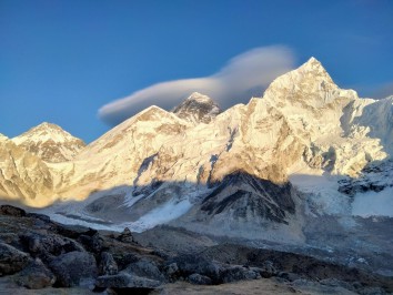
The trail to the Gokyo Ri viewpoint begins with a short walk around the lake. Set out early (to avoid mid-morning cloud) for the two hour climb to its summit. A panoramic view the glacier lies beneath the unforgettable vista of the Mahalangur Himal that includes Cho-Oyu (8 201m) the ice wall and Ghyachung Kang (7 952m), the north face of Everest (8 848m/29 028ft), Lhotse (8 516m), Nuptse (7 861m), and Makalu (8 463m), while to the south Cholatse, Taboche, Thamserku, Kangtega, KusumKangru (all over 6 300m) and many more, some unnamed, rear their peaks.
After breakfast at the teahouse trek south, beside the moraine, gradually losing altitude. At the second, TabocheTsho (4 710m), a trail heads over the moraine to Tagnag. The edge of the LongpongaTsho(4 690m) is crossed on a bridge. Later, the snout of the moraine is reached and the trail drops to the valley floor to cross a river. At Pangka (4 390m) the trail splits – the right hand path climbs gradually to a ridge. Look back for the last views of Cho Oyu before descending to Machhermo in a broad valley. Dwellings are spaced within stone walled fields. Impressive Kangtega and Thamserku rise south of the valley. Overnight in Machhermo.
The scrub vegetation that confirms the altitude will gradually give way to more verdant growth as the trail descends to Dole (4100m). Below, enter pine and rhododendron forests towards PhortseThenga (3 680m) on the slopes of sacred Khumbila and up to Mong La (3 975m, with a central chorten) then back to Sanasa (3 780m). The final broader trail now contours around the mountain back to Namche Bazaar. Overnight in Namche.
After an early breakfast, descend to more comfortable altitudes, passing through the friendly villages of Jorsale (2 830m, exit from the National Park), Monjo (2 840m) and Phakding (2 610m). Cross the suspension bridge at ThadoKoshi before rising to Ghat (2 530m) and Cheplung (2 700m). Descend and then climb steeply back to Lukla: where your porters will take their leave. Overnight in Lukla.
After an early breakfast, take the return flight to Kathmandu. Transfer to your hotel. Rest of day free.
Transfer to Tribhuvan International Airport for your flight to your next destination.
NB: Cloud and turbulent weather along the mountain ranges is common and may lead to internal mountain flight delays or cancellations. We suggest you allow at least one extra day after your trek before flying out of Nepal.

Been planning this adventure for a few months, after emailed over dozens of trekking companies, I came across Landmark Discovery Treks. Prem (owner) was very quick to response to all my inquiries and the price was very reasonable. Prem is also very accommodating, he was happy to follow my itineraries and weeks leading to the start of the trekking, I wanted to change the trekking dates, with no question asked, Prem rearranged everything for me. I was well looked after from the arrival to departure in Kathmandu.
During the trek, I was well looked after by my guide, Mahesh. He always made sure I have enough to eat and always there to give me advices as what to eat to help reduce the risk of altitude sickness. Accommodation was basic but very cleaned and sometimes with bathroom attached so that was a bonus! I have to thank Mahesh for helping me carried extra things when I really struggled.
So thank you Prem and Mahesh for the amazing trip.
I highly recommend Landmark Discovery Treks to anyone for their excellent services and reasonable pricing.
thuyisahappysunshine
25th Apr, 2022